

Showing posts with label Portfolio. Show all posts
Showing posts with label Portfolio. Show all posts

Model Maker #1 - 2 storey 3 bed terrace
The Urban Refine Model Maker is launched! I will be creating a series of flat pack house models that can be easily assembled and used to make simple models.


Ring Roads
The other day I can across this nice little image of the ring roads of the world by Rice school of architecture.

And I decided to do one for the cities of Great Britain.

Ring roads are significant features within cities and very often form the centre piece of a cities movement network. They do however only ever form part of the vehicle network and often little consideration is given to how pedestrians and cyclists will cross the ring road barrier. All to often pedestrians and cyclists will be forced into an underpass or overpass, which very few of us ever want to do.
CharacterLess Areas

Thought it was interesting looking at a character area plan without a base. I though it was surprisingly informative, but maybe that's because I know what the masterplan looks like? I would be interested in seeing others!


Portfolio: A round Plan
Aspirations for Garden Cities of Today

Based on Ebenezer Howard's Garden Cities plans, an illustration for an eco-borough in Yorkshire.
Village Life

A simplified land use plan for a village that zones areas in order to quickly analyse adjoining land uses.

Based on Ebenezer Howard's Garden Cities plans, an illustration for an eco-borough in Yorkshire.
Village Life

A simplified land use plan for a village that zones areas in order to quickly analyse adjoining land uses.
Portfolio - Historic Plans

This plan represents the growth and change of a village over the past 100 years. Like a jigsaw each part of the plan (different coloured areas) shows how the village has grown, generally with the more historic elements maintaining promenance at the top of the plan. The village then grows up behind (and in reality the place becasue of) these historic elements.
Competition: Sheffield Cooling Towers


The vision for the site was conceived and generated by the stronghold nature that has grown on the site and the important role the site has built in supporting local ecosystems. This rich organic world contrasts heavily with the former industrial and environmentally destructive role of the site, demonstrating the resilience of the natural world. The vision therefore, is firstly to respect the unquestionable strength of the feral environment and wildlife within the site. To then support and reinforce this by establishing it as a unique green enclave within its undeniably human dominated surroundings. Human influence is through interaction and enjoyment only, encouraging local habitats to adapt, grow and bloom. Round About the Garden strives to minimise all impact on the natural environment, in its detailed design, construction and ongoing maintenance and life cycle.
The proposal is dominated by large zones of landscaping, in addition to existing areas of established woodland, creating a green lung for the area. Indigenous planting will eventually prosper into mature woodland, capable of sustaining a complex ecology system by encouraging existing wildlife to thrive and new ecosystems to establish. These areas of woodland will have varied characters throughout the site dependent on factors such as topography, proximity to water and solar orientation. Contrasting overgrown and wild areas with more formal areas of both new planting and existing woodland, it will create a lush sanctuary alongside the cascading waters that flow through the site.
Round About the Garden is conceived as a place of discovery, play and intrigue. A network of paths at ground level and elevated within the treetops afford a chance to explore the wooded areas saturating the site. The snaking footpaths inadvertently guide pedestrians from one place to other; with surprises beyond every tree and above each canopy. It will be a unique experience for each visitor, defined by individual impulse and distraction. Openings in the woodland yearn to be discovered by those who choose to explore, with a series of towers peppered through these areas inviting people inside. Round About the Garden will be an inclusive place, with all paths linking back to a public transport system, including new tram stops and Meadowhall Interchange. They also interconnect into the underground car parks on the site, cycle routes and the waterway footpaths, giving access to all.
A series of towers, woven into the landscape at strategic points are conceived; some peeping through the treetops whilst others sit comfortably sheltered by surrounding leaves, hidden by the flourishing woodland. The new towers echo the iconic presence and status of the cooling towers, redesigned to fit in with the natural environment. The towers collectively are physically linked spaces following the topography of the landscape, with common architectural features and form. However each tower will be unique, with an individually defined function interpreted differently by the visitor; a looking tower, a chance for respite, a captured view over the treetops, a climbing frame, gallery space…. The towers are a crucial element of the site and must be detailed individually as a design competition project. This will have involvement from the local community encouraged at all stages, giving a great sense of local pride in these architectural gems.
Being such an historically integral element of the towers, water is an important element of the scheme with a constant presence throughout the site. Used to enhance the sculptural form of the cooling towers, to guide visitors, support and enhance local ecosystems and also to enable trade and servicing of the towers. Water also acts as a soothing presence throughout the site, calming the mind and drowning out the din of the motorway. Spiralling pipes filled with falling water cascades around the towers to generate hydro electricity reflecting past usage of the cooling towers, making part of the energy generation process once more.
The cooling towers are recognised as local and national icons and as such the site maintains and embraces their imposing presence from the west. Whilst the proposal is to radically alter their physical form with a cut through the eastern edges of the towers. In doing so, the inner workings and function is exposed to visitors of the site, conveying their immense scale and undeniable power. Visitors will be tempted and encouraged to enter the towers, and will be elevated into the clouds, experiencing performance workshops, art and exhibition spaces for local artists, conferences and workshops, botanical gardens and viewing platforms at the very top.
Round About the Garden will be a green haven in an urban context and will provide a great opportunity for development. By cutting the cooling towers into a more dynamic and exposed form they can afford a variety of accommodation whilst ensuring the site continues to be enveloped by nature. The height of the towers affords a high density of development and alongside other strategically placed buildings will allow the site to be economically and socially sustainable. The discreet location of new workshop buildings, along with their associated underground parking ensures that a strong sense of ‘garden’ is maintained throughout the site. The excellent movement links surrounding the site are exploited, with an emphasis on sustainable forms of transport, to ensure that new roads are not introduced at a detriment to the more important vision of nature.
We reached the Final 15 with this entry, and from what we could gather gained a lot of the publics support for this scheme when it was presented at Sheffield's Meadowhall.
Typography of Masterplans
After seeing my good friend Panos experiment with typographical architecture, I thought it would be interesting to have a go at typographical masterplanning.
1. The base

2. Add the typography

3. The typographical masterplan

Although I think the experiment has produced an interesting result, I cant say it has produced a clear, legible plan when viewed as a single entity. However while playing around with the layers I noticed that maybe less is sometime more.
Figure Ground Plan

Road Network

Landscape
Public Realm
You can also get interesting but equally illegible results by maintaining a single colour.
1. The base

2. Add the typography

3. The typographical masterplan

Although I think the experiment has produced an interesting result, I cant say it has produced a clear, legible plan when viewed as a single entity. However while playing around with the layers I noticed that maybe less is sometime more.
Figure Ground Plan

Road Network

Landscape

Public Realm

You can also get interesting but equally illegible results by maintaining a single colour.


Playing with Squares
I came across these sketchup models which I remember creating 2 years ago after reading Jan Gehls "Life Between Buildings" and seeing this drawing. 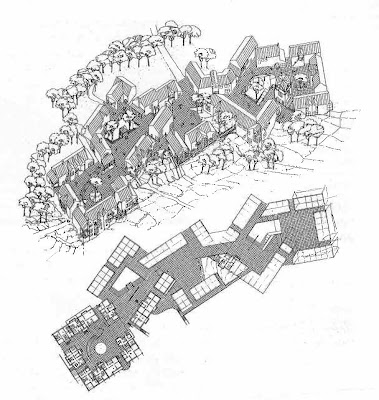
It shows how the subdivision of residential areas in Scandinavian housing schemes into groups of 15-30 dwellings has been found to work quite well in encouraging social networking. I stating thinking about this and how the rotation of these squares on only creates an interesting visual place but also one good for social interaction. So I started playing with this idea of simply rotating a series of squares along a street to see what kind of place I can up with.
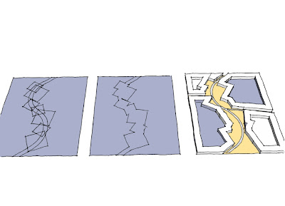
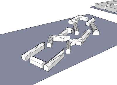
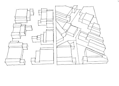
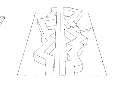

It shows how the subdivision of residential areas in Scandinavian housing schemes into groups of 15-30 dwellings has been found to work quite well in encouraging social networking. I stating thinking about this and how the rotation of these squares on only creates an interesting visual place but also one good for social interaction. So I started playing with this idea of simply rotating a series of squares along a street to see what kind of place I can up with.


Book Notes: Rossington's Radial Rational
Throughout history, town planning and urban design have rested on two main principles; a concern for urban form and the ideal city in architectural terms; and a search for the ideal community. Many of the human settlements that have developed as a result of the move from a nomadic existence to an agricultural one have displayed various degrees of design consideration in their layout and function. The earliest examples of these can be traced back as far as the third century BC with the ancient Mesopotamian (modern day Iraq) and Harrapan (India) civilizations.
The ideal city concept emerged in ancient Greece and was typified by the city of Athens, although like many other cities during this period it was not consciously ‘designed’ but grew in an organic nature in reaction to the acropolis. Plato, however in his dialogues on political theories and the ideal city clearly describes a consciously planned radial city known as the lost city of Atlantis. In Atlantis, the acropolis was also placed in the centre of the settlement and was surrounded by a circular wall and a series of concentric islands divided by waterways which linked into the surrounding ocean. Each concentric island had a clearly defined function (the small inner ring consisted of gardens and temples, the middle island was a military base and the outer ring predominantly agricultural land).
During this time religious beliefs influenced city design and circular cities were associated with cosmic alliance. Therefore the centre of Atlantis held great importance and is an excellent insight into the values of that society. In ancient Greek cities an urban space known as an "agora" would represent the centre of the city and in its function was the heart of the city where social life, business and politics would be discussed and debated. Where a central authority holds power it is common for a palace or temple to occupy the centre. A series of concentric roads can then cut the city up and allow the population to be situated at varying distances from this political centre on the basis of rank and status.
The Greeks themselves did not build any radial ideal cities, neither did the Romans who rejected a circular radial layout in favour of the square grid. During this time the circle and square were hailed as the most perfect geometric shapes because of the work of Marcus Vitruvius Pollio, a Roman writer, engineer and architect on the relationship between proportion and beauty. He recognised that nature’s designs were based on universal laws of proportion and symmetry and symbolized this with an image of a spread-eagled man whose extremities would touch the perimeters of these perfect circle and square figures.
During the Renaissance Leonardo da Vinci popularised this concept with his famous drawing of the Vitruvian Man, and the notion that cities should be designed accordingly with work and life taking place in an ideal space that responds to the rhythm of life. The Renaissance theorists also believed that the workings of the human body could be analogous to the workings of the universe (whereby the square symbolized material existence with lines and right angles expressing will, order and subordination and the circle represented spirituality and a continual cycle of life). As a result, the European Renaissance saw the re-emergence of the ideal city in the form of a radial plan as a diagram of humanist perfection.
In addition to this and more commonly in Renaissance times, the radial city plan was encouraged by military engineers due to its defensive capabilities. Francesco di Giorgio was the first Renaissance architect and military engineer to articulate the ways in which a radial system of streets, a bastioned periphery wall, and a public space in the centre could work together.
The use of a radial layout for the convergence of traffic had been apparent since the Middle Ages in merchant towns with a centralised market place. The widespread use of the stage-coach in the Baroque era facilitated a post-war function for the radial plan as an acceptable city diagram. Its prominence in transport terms was further elevated by the transformation of the city centre into a business district and the introduction of more rapid forms of transport such as the automobile, which emphasised the need for a more coherent system of radial traffic arteries. Due to this development in transportation and the redundancy of city defences, the walls of many previously fortified cities were pulled down and the land turned into a continuous ring road. The majority of the old approaches from the countryside into the city were rationalised into straight radial roads linking the centre to the growing suburbs.
Out of the industrial age came the re-emergence of the ideal city in the form of Ebenezer Howard’s Garden City Movement of 1898. The origins for this movement arose out of Howard’s concern for the poor quality of life in the industrial city and proposed the construction of new self sustaining satellite towns where people could enjoy the benefits of both the town and countryside. The concept of the Garden City consisted of a radial plan divided by six large tree lined boulevards traversing the city from the centre to the rim and split the city into six wards. With an emphasis on community the large public buildings such as the town hall, hospital and library set in large parklands would sit at the centre of the city in the location most accessible to the entire population. Running around the edge of the parkland was to be a wide glass arcade that would house the cities retail and leisure facilities, with the furthest city inhabitant living only 5-10 minutes walk of this ‘crystal palace’. The rings beyond this would consist mainly of residential developments of large well lit and high quality housing and have educational, religious facilities and further parkland interspersed throughout. The outer ring of development would contain the cities factories and industrial sector like the crystal palace the furthest an inhabitant would live from these would be 5-10 minutes walk. Beyond the city would be open countryside designated as green belt to stop the city expanding so that its self sufficiency could be maintained. The Garden Cities were linked to a central city through routes radiating from its centre through a series of rapid transport routes. The outlaying Garden Cities were linked to one another via electric trams by a direct road route and railway lines.
It was around the time of the Garden City Movement that Doncaster’s philanthropic colliery owners started to build housing for their workers. In 1907 Percy Houfton designed Woodlands model village for the workers of Brodsworth Colliery and was seen in its day as an exemplar piece of urban planning and was directly influenced by the Garden City Principles of tree lined boulevards and high quality housing. It was also around this time that the colliery housing at New Rossington was being built with ‘The Circle’ as its centrepiece (much of this area was constructed in the 1920s and 30s). The Circle - the most conspicuous pattern of urban grain in this area and which emerged at this time in reaction to modernist design thinking and the Garden City ideals - has a strong radial plan with a green space at its centre and a number of large residential properties, a church, public house and community hall encircling the central space. Around this inner ring are two rings of terraced residential properties before the plan merges back into a more traditional grid layout. In the corner spaces left over from the transition between square and circle are located further community buildings and the market place and the retail centre located along the circles northern axis. Although there are no references in historical texts about any influences on New Rossington’s housing layout the area does seem to embody an element of the Garden City philosophy with rings of housing around an area of greenspace and community buildings.
The ideal city concept emerged in ancient Greece and was typified by the city of Athens, although like many other cities during this period it was not consciously ‘designed’ but grew in an organic nature in reaction to the acropolis. Plato, however in his dialogues on political theories and the ideal city clearly describes a consciously planned radial city known as the lost city of Atlantis. In Atlantis, the acropolis was also placed in the centre of the settlement and was surrounded by a circular wall and a series of concentric islands divided by waterways which linked into the surrounding ocean. Each concentric island had a clearly defined function (the small inner ring consisted of gardens and temples, the middle island was a military base and the outer ring predominantly agricultural land).
During this time religious beliefs influenced city design and circular cities were associated with cosmic alliance. Therefore the centre of Atlantis held great importance and is an excellent insight into the values of that society. In ancient Greek cities an urban space known as an "agora" would represent the centre of the city and in its function was the heart of the city where social life, business and politics would be discussed and debated. Where a central authority holds power it is common for a palace or temple to occupy the centre. A series of concentric roads can then cut the city up and allow the population to be situated at varying distances from this political centre on the basis of rank and status.
The Greeks themselves did not build any radial ideal cities, neither did the Romans who rejected a circular radial layout in favour of the square grid. During this time the circle and square were hailed as the most perfect geometric shapes because of the work of Marcus Vitruvius Pollio, a Roman writer, engineer and architect on the relationship between proportion and beauty. He recognised that nature’s designs were based on universal laws of proportion and symmetry and symbolized this with an image of a spread-eagled man whose extremities would touch the perimeters of these perfect circle and square figures.
During the Renaissance Leonardo da Vinci popularised this concept with his famous drawing of the Vitruvian Man, and the notion that cities should be designed accordingly with work and life taking place in an ideal space that responds to the rhythm of life. The Renaissance theorists also believed that the workings of the human body could be analogous to the workings of the universe (whereby the square symbolized material existence with lines and right angles expressing will, order and subordination and the circle represented spirituality and a continual cycle of life). As a result, the European Renaissance saw the re-emergence of the ideal city in the form of a radial plan as a diagram of humanist perfection.
In addition to this and more commonly in Renaissance times, the radial city plan was encouraged by military engineers due to its defensive capabilities. Francesco di Giorgio was the first Renaissance architect and military engineer to articulate the ways in which a radial system of streets, a bastioned periphery wall, and a public space in the centre could work together.
The use of a radial layout for the convergence of traffic had been apparent since the Middle Ages in merchant towns with a centralised market place. The widespread use of the stage-coach in the Baroque era facilitated a post-war function for the radial plan as an acceptable city diagram. Its prominence in transport terms was further elevated by the transformation of the city centre into a business district and the introduction of more rapid forms of transport such as the automobile, which emphasised the need for a more coherent system of radial traffic arteries. Due to this development in transportation and the redundancy of city defences, the walls of many previously fortified cities were pulled down and the land turned into a continuous ring road. The majority of the old approaches from the countryside into the city were rationalised into straight radial roads linking the centre to the growing suburbs.
Out of the industrial age came the re-emergence of the ideal city in the form of Ebenezer Howard’s Garden City Movement of 1898. The origins for this movement arose out of Howard’s concern for the poor quality of life in the industrial city and proposed the construction of new self sustaining satellite towns where people could enjoy the benefits of both the town and countryside. The concept of the Garden City consisted of a radial plan divided by six large tree lined boulevards traversing the city from the centre to the rim and split the city into six wards. With an emphasis on community the large public buildings such as the town hall, hospital and library set in large parklands would sit at the centre of the city in the location most accessible to the entire population. Running around the edge of the parkland was to be a wide glass arcade that would house the cities retail and leisure facilities, with the furthest city inhabitant living only 5-10 minutes walk of this ‘crystal palace’. The rings beyond this would consist mainly of residential developments of large well lit and high quality housing and have educational, religious facilities and further parkland interspersed throughout. The outer ring of development would contain the cities factories and industrial sector like the crystal palace the furthest an inhabitant would live from these would be 5-10 minutes walk. Beyond the city would be open countryside designated as green belt to stop the city expanding so that its self sufficiency could be maintained. The Garden Cities were linked to a central city through routes radiating from its centre through a series of rapid transport routes. The outlaying Garden Cities were linked to one another via electric trams by a direct road route and railway lines.
It was around the time of the Garden City Movement that Doncaster’s philanthropic colliery owners started to build housing for their workers. In 1907 Percy Houfton designed Woodlands model village for the workers of Brodsworth Colliery and was seen in its day as an exemplar piece of urban planning and was directly influenced by the Garden City Principles of tree lined boulevards and high quality housing. It was also around this time that the colliery housing at New Rossington was being built with ‘The Circle’ as its centrepiece (much of this area was constructed in the 1920s and 30s). The Circle - the most conspicuous pattern of urban grain in this area and which emerged at this time in reaction to modernist design thinking and the Garden City ideals - has a strong radial plan with a green space at its centre and a number of large residential properties, a church, public house and community hall encircling the central space. Around this inner ring are two rings of terraced residential properties before the plan merges back into a more traditional grid layout. In the corner spaces left over from the transition between square and circle are located further community buildings and the market place and the retail centre located along the circles northern axis. Although there are no references in historical texts about any influences on New Rossington’s housing layout the area does seem to embody an element of the Garden City philosophy with rings of housing around an area of greenspace and community buildings.


The Blackout Bus
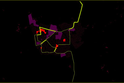
This plan represents the most accessible places in a town. The red and purple areas represents the destinations and the green line the bus route. The line increases in thickness the more bus routes travel along that section. A destination that has a thin line next/through it is less accessible (has fewer buses going past) than destinations with thicker lines (more buses going past).

The Blackout
Recently I have been experimenting with a new graphic style to allow the message the plan is trying to convey more legible and easier to 'spot'. This has involved using colours of various brightness on top of a dark base. The paths or spaces at the top of the hierarchy are assigned the brightest (more contrasting with black) colours, with them getting gradually darker the further down the hierarchy you go. This results in a plan where the most important elements contrast and stick out from the dark background, and the less important elements almost indistinguishable from it.
Below the most used/public green spaces are in the brightest with the lesser/more privatised spaces getting gradually darker. This plan not only shows where the most used spaces are and where there is a lack of greenspace, but also how the spaces connect with each other and which spaces need to be improved/expanded to create a stronger green network.
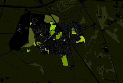
Below the technique allows you to easily identify the movement hierarchy of a town and the 'voids' of space where new connections are needed. 
Below the most used/public green spaces are in the brightest with the lesser/more privatised spaces getting gradually darker. This plan not only shows where the most used spaces are and where there is a lack of greenspace, but also how the spaces connect with each other and which spaces need to be improved/expanded to create a stronger green network.

Below the technique allows you to easily identify the movement hierarchy of a town and the 'voids' of space where new connections are needed.

Subscribe to:
Posts (Atom)


